Around 70% of the world’s population will live in towns and cities by 2050. This would indeed place an increasing pressure on land to support development. Reports suggest that buildings consume one-third of the world’s total energy. It accounts for over 38% of all energy-related carbon dioxide emissions. Enhancing the energy efficiency of buildings, both new and existing, has become a global priority today to minimize environmental impact and provide long-term sustainability. But how does 3D mapping promote sustainable urban development and renewable energy? Let’s see.
Geospatial technology and data have become ubiquitous in this digital era for project management. The solution is to leverage the benefits of geospatial technologies to promote sustainable urban development. The convergence of 3D BIM, geospatial, and energy modeling is enabling designers to reduce the carbon and energy footprints of existing and new structures. Our technology has evolved tremendously, and by using the right data we can build highly- energy-efficient structures.
A BIM (Building Information Modeling) approach to modeling could be a potential solution for the impending problems we face with buildings and energy efficiency. Environmental analysis and several other certification programs like BREEAM and LEED require natural lightning, solar radiation, wind, renewable energy, and noise analysis, all of which require the integration of geospatial information. This data, along with local climatic conditions with the building design information is gathered, stored, and used in BIM.
Moreover, by bringing unmatched detailings in instructions, 3D Modeling allows businesses to make collision-free plans of the infrastructure. For instance, in the case of solar panel installation, a 3D mapping not merely shows how it looks but also maps the movement of shadows over the site during a day. This offers designers an accurate perspective to create an optimal design, making the most efficient use of the space. The accurate prediction of the solar energy generated using the rooftops of buildings is a paramount tool for several researchers, decision-makers, and investors for creating sustainable cities and societies.
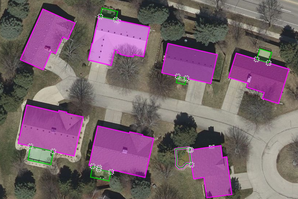
Mapping the Solar Potential of Rooftops, one rooftop at a time
Thanks to new and faster mapping techniques, sustainably addressing rapid urbanization has never been so seamless and accurate. With detailed 3D mapping, engineers and builders are completely aware of the environment they would be dealing with. With 3D terrain models, the depiction of terrains, elevation, and slopes become factual.
Precisely, geospatial data is inevitable in implementing a sustainable infrastructure of roads, water, waste, and power. Offering a single source of accurate, environmental information fuels up the process of decision-making for governments, authorities, or policymakers.
The significance of 3D geospatial data is not limited to a better understanding of the infrastructure models but is also used as an input by engineers in complex construction works. The maps are keenly based on accurate measurements and scaled as per project requirements. This offers industry professionals a realistic view of a site, to accurately manage a project’s feasibility, costs, and scheduling.
Smart city projects that are emerging worldwide are examples that we are going on the right path to sustainable urban development. The significance of 3D mapping and geospatial data for creating these smart cities is just paramount. Using real-world visualizations for conducting analysis and design improvements of infrastructure helps companies focus on excellent development and usage of land in sustainable ways.
3D GIS for Environmental Planning for Sustainable Urban Development
How to get a bigger picture of the performance of a building at its location in its expected climate?
An analysis of the geographic location and orientation of the building, collected by 3D mapping along with the local historical insolation and weather information including temperature, moisture, wind, and psychrometric data would generate this information. This is crucial in creating a working hypothesis about a building’s energy behavior. It also helps in finding the right gaps opened with an opportunity for energy savings, including water infrastructure, daylighting and lighting efficiency, renewable energy generation, waste, and efficiency.
The energy analysis leverages the geographical location of the building with the local environmental conditions and performs thermal, lighting, and airflow simulations. This helps in estimating the amount of energy a building will consume in a year and further tests design options to identify the best possible solutions to conclude energy use, CO2 emissions, occupant comfort, light levels, airflow, and LEED certification level.
Studies have proven that energy analyses and testing alternative options allow projects to reduce annual energy consumption and power bills by 40%, certainly a stepping stone for sustainable urban development.
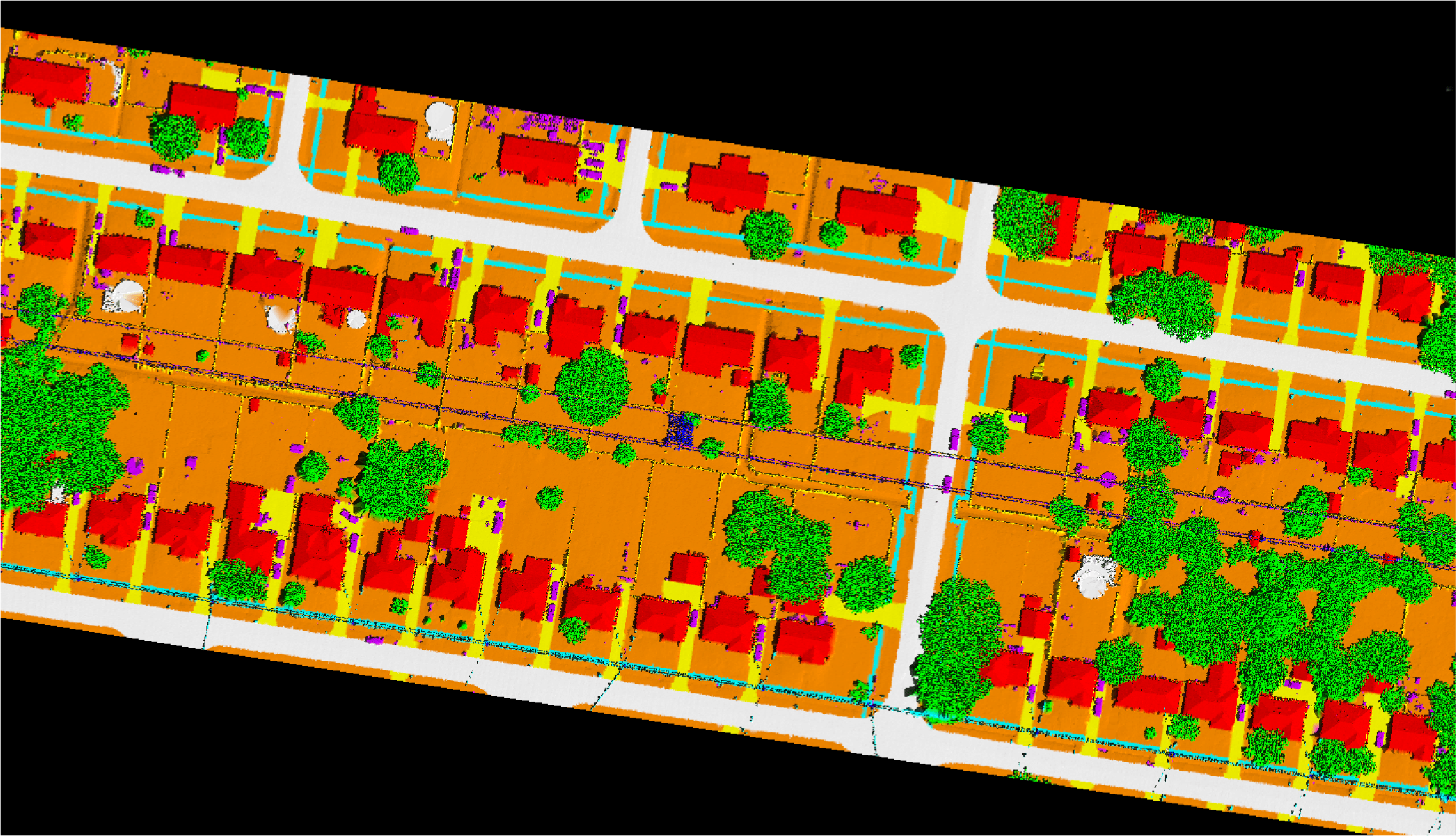
A building is always integrated with other infrastructure such as the transport system, utilities, environment surrounding, etc. Curating data that integrates all this has become a necessity today. This is where 3D mapping comes into the picture, a machine vision technology that can profile objects in 3D to map them in real-world scenarios. The information contained within a detailed 3D model facilitates builders with the accurate data to coordinate utilities, grading, and system routing information accurately.
The significance of urban planning in creating sustainable environmental practices is inevitable and geospatial technologies will have a huge impact on sustainable urban development. The data captured using industry-standard acquisition methods and techniques is processed into meaningful 3D models with details on attributes, measurements, and location using 3D city modeling software. In the backdrop of global warming, understanding the importance of optimizing energy efficiency is essential.
Companies like Magnasoft have been offering high-dimensional 3D mapping services to help engineers in visualizing all the elements of a project, especially renewable energy sites. Our urban mapping solutions have helped government bodies to focus on development, especially in lands with limited spaces. We have delivered 3D modeling projects covering around 80% of cities globally, capturing data using 3D Mobile LiDAR & UAV (unmanned aerial vehicle) or drone for creating base maps.
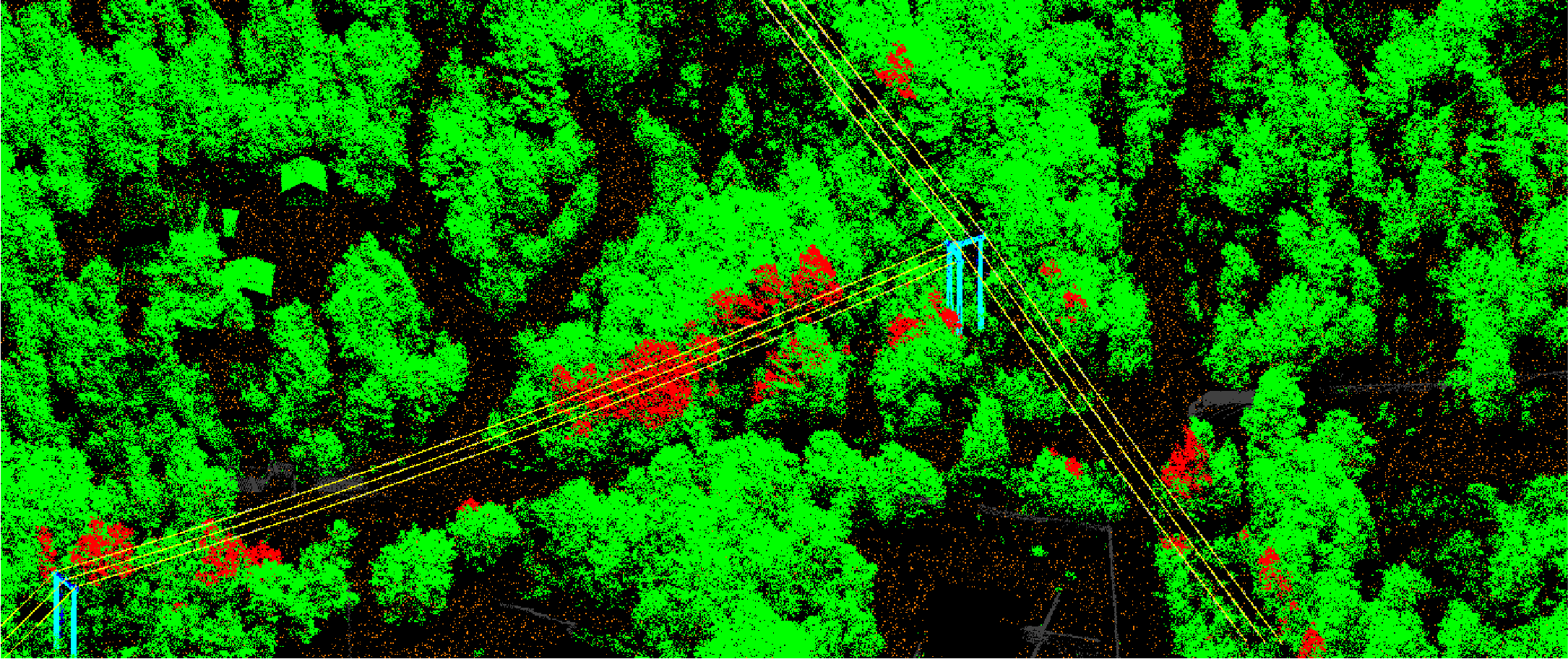
Urban Vegetation Mapping can be the basis of Green Infrastructure Planning
With the renewed focus on climate change, renewable start-ups have expanded their focus beyond clean energy to energy independence. The ability to maximize the utilization of geospatial technologies is the fuel that powers this energy independence. It plays a key role in supporting the development and expansion of wind, solar, and hydro energy.
By monitoring the process, ensuring that renewable energy generation sites are optimally sited, and affirming that the power generated is delivered efficiently, geospatial data offers a clear insight into the gaps where energy can be saved and sustained.
For instance, wind turbines should be located in places with consistent wind resource availability and variability. This includes understanding the air volume, velocity, and density. Using the best topographic information and precision mapping, one can seamlessly locate wind turbines in highly desirable sites.
Jason S. Rodriguez, CEO, and Director of Research of Zpryme, a research and consulting firm, quoted that, “the growth of the renewable energy space is going to open doors for Smart Grid vendors and manufacturers who can provide niche systems, software, and equipment that can integrate renewable energy sources in the Intelligent Utility ecosystem.”
Cities and industries across the globe are realizing the significance of geospatial insights and are working towards reducing carbon footprints by leveraging the best out of it. Masdar in the UAE is working on an ambitious plan to build a Masdar City, located 30 kilometers from Abu Dhabi city. Committed to meeting the goals of zero waste, sustainable living, and carbon neutrality, the company is extensively using the Geographic Information System (GIS) to design this future city.
Numerous renewable energy options are available today, but the performance of these various options depends on location-based variables, implying the necessity for geospatial analysis. Geospatial technology is proving to be an essential component of the decision-making process in every project. It enables designers to significantly reduce the energy footprint of existing structures, including historic buildings and new designs.
It’s high time that we realize that the “Geospatial way” is certainly the future, and the most efficient way to collect, process, and utilize information to promote sustainable urban development on a global scale. Well, one cannot deny Jack Dangermond when he said, “GIS is waking up the world to the power of geography, this science of integration, and has the framework for creating a better future.”
Interested to know more about Magnasoft’s location and 3D mapping services. Click here and connect with us now.