In the dynamic landscape of urban development, a new era is unfolding where Artificial Intelligence (AI), Augmented Reality (AR), and Virtual Reality (VR) are transforming the fabric of city planning and management. “Geospatial Mapping for City Development: Embracing Technological Innovations” captures this paradigm shift, where advanced technologies are not just tools but catalysts reshaping our urban spaces. These innovations offer a new lens to view and interact with our cities, making them more responsive, efficient, and sustainable. Through the precision of geospatial mapping, we are crafting urban environments that cater to the evolving needs of their inhabitants, leveraging technology to ensure livability, environmental friendliness, and resilience. Join us on this journey to explore how the integration of AI, AR/VR, and geospatial technologies is paving the way for the future of urbanization.
Geospatial Services at the Core: At the core of contemporary urban development lies the sophisticated use of advanced geospatial services. These services employ real-time sensor-based capabilities and comprehensive databases that are operational round the clock. This seamless integration of technology and urban planning marks a significant leap towards modern city management.
Geospatial technologies are crucial in modern urban development, serving as the backbone of city infrastructure and transforming urban environments into data-rich landscapes. Real-time data collection through sophisticated sensor networks enhances urban elements, improving mobility, security, and overall quality of life. Moreover, these technologies are in a state of constant evolution, marked by significant advancements in 3D modeling, LiDAR, mobile mapping, remote sensing, high-resolution satellite imagery, and photogrammetry. These advancements are not merely responses to urban growth; they represent a proactive reshaping of cities for sustainable futures. Integral to efficient urban planning and infrastructure development, these technologies are synergizing with AI and AR/VR innovations, forming the backbone of intelligent, resilient, and sustainable cityscapes.
The convergence of Artificial Intelligence (AI), Augmented Reality (AR), and Virtual Reality (VR) with geospatial data brings a new dimension to urban management. AI delves into the sea of data to unearth patterns and insights crucial for the upkeep and monitoring of city infrastructure. AR and VR, on the other hand, offer a groundbreaking approach to city planning. Through these technologies, urban planners and architects can visualize new infrastructures and plan for the future with unprecedented precision. Moreover, they become indispensable tools in emergency response and disaster management, enhancing decision-making capabilities through realistic simulations.
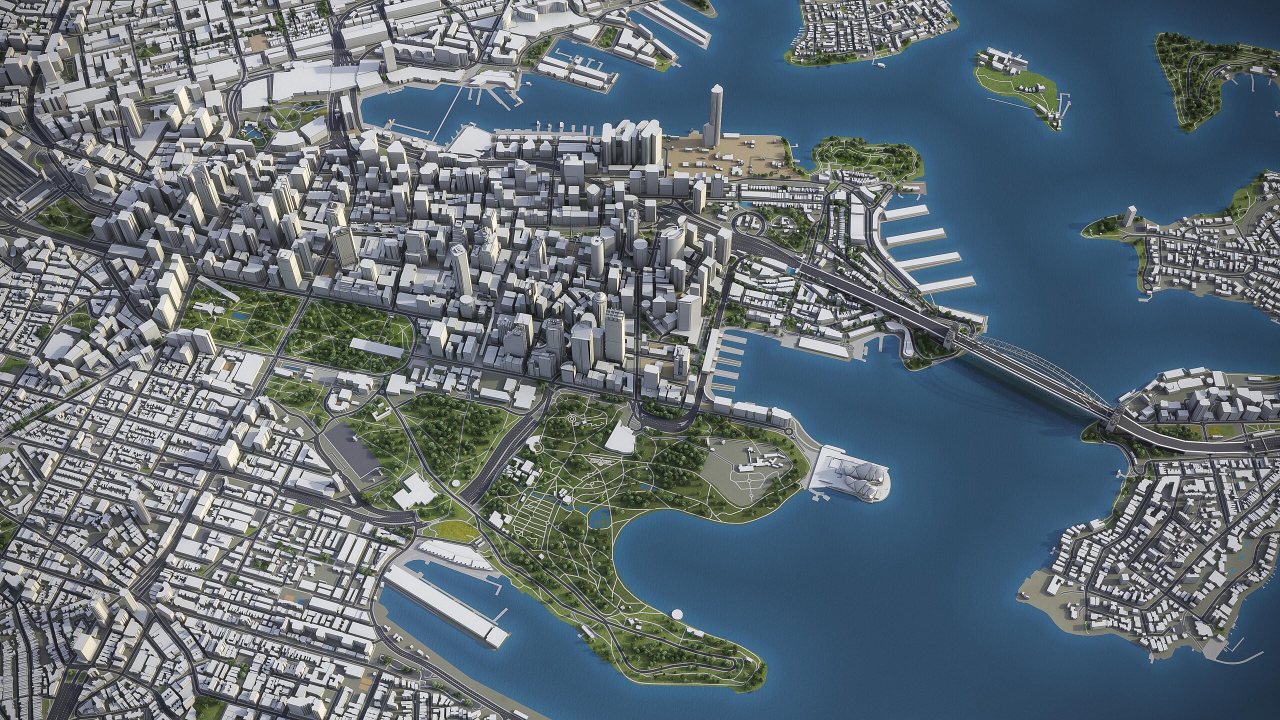
A prime example of the impact of geospatial technologies in smart cities is Magnasoft’s project for a client in London. This endeavor entailed developing a highly detailed 3D model of the city at Level of Detail (LOD) 350. It captured intricate architectural features and minor structural components essential for asset management, detailed visualization, and in-depth urban planning. The project’s multi-phase structure was instrumental in maintaining a high level of detail while ensuring an efficient workflow, demonstrating the transformative potential of geospatial technologies in urban development.

For more details on this innovative project, click here.
As we look towards the future, the evolution of urban development is inextricably linked to the advancements in geospatial mapping technologies. The next wave of innovation is set to redefine our urban landscapes, making them more responsive, efficient, and sustainable.
Emerging technologies like Artificial Intelligence (AI) and Machine Learning (ML) are being integrated into geospatial systems, enabling more dynamic and predictive models of urban environments. These technologies are not just about mapping the physical space but understanding and anticipating the needs and patterns of urban life. For instance, AI-driven geospatial analytics can help forecast traffic patterns, optimize public transportation routes, and plan for emergency response.
The integration of Internet of Things (IoT) with geospatial mapping is another frontier. Sensors embedded across the cityscape will provide real-time data, feeding into geospatial models to monitor everything from air quality to the structural health of buildings. This will lead to smarter resource management and proactive maintenance of urban infrastructure.
Augmented Reality (AR) and Virtual Reality (VR) are also set to play a crucial role. By overlaying digital information in the real world, AR can enhance the experience and interaction of individuals with their urban environments. VR, on the other hand, will enable city planners and architects to experiment and visualize urban changes before they are implemented.
Furthermore, advancements in satellite imaging and drone technology will provide higher-resolution data, allowing for more detailed and frequent updates to geospatial maps. This will improve decision-making processes, urban planning, and environmental monitoring.
As we move forward, these advancements in geospatial mapping are poised to make cities not just more efficient and sustainable but also more adaptable and resilient. The future of urban living will be shaped by our ability to harness these technologies, creating cities that are not only smart in their use of data but also in their response to the needs and challenges of their inhabitants. Are you ready to be part of this transformative journey? Explore how geospatial technologies can enhance your urban projects and contribute significantly to the evolution and enhancement of city development. Contact us to learn more and take your first step toward building the cities of tomorrow.