Introduction: A Pressing Challenge
In our hyper-connected world, the power to keep the lights on is not just about providing a service; it’s about safeguarding economies and ecosystems. A growing challenge to this vital utility is vegetation-related outages. Overgrowth and encroachment of vegetation into overhead power lines account for a significant proportion of power disruptions and can lead to devastating wildfires. The economic toll of these outages is severe, with the Department of Energy estimating that power outages cost the U.S. economy as much as US$ 150 billion annually. Accenture analysts add to this grim picture, estimating utilities’ annual spend on clearing vegetation from overhead lines at a staggering $6 billion to $8 billion. The cost implications are clear: this issue demands immediate and innovative solutions.
The Stakes: Costs of Outages and Vegetation Management
Furthering our understanding of the economic stakes, an IDC Research survey found that for a third of respondents, the cost of a typical transmission and distribution (T&D) outage exceeds US$ 100,000. Yet, the cost can escalate into millions of dollars per hour during significant outages. These figures underline the scale of investment in vegetation management and the economic fallout of power outages. With the cost of vegetation management continuing to grow each year, effective solutions are not just desirable – they are imperative.
FERC’s Recommendations: Time for a Shift in Approach
The Federal Energy Regulatory Commission (FERC) recognizes the pressing need for an overhaul in vegetation management practices. In fact, according to FERC, strategic vegetation management could prevent as much as 50% of power outages resulting from vegetation interference.
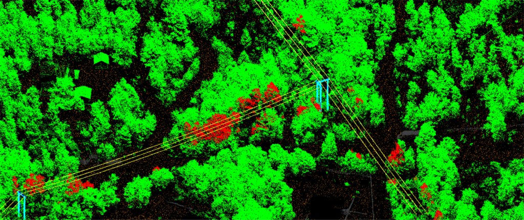
Embracing LiDAR and Remote Sensing Analytics
At the heart of this shift is the innovative combination of LiDAR (Light Detection and Ranging) and remote sensing analytics. LiDAR, which uses pulsed laser light to measure variable distances, creates intricate 3D representations of the Earth’s surface.
With the help of advanced algorithms, remote sensing analytics can analyze LiDAR data and satellite imagery in real-time. This allows utility companies to track vegetation growth rates, anticipate potential threats, and mitigate outages before they occur. This data-driven approach represents a proactive shift away from previous reactive models, reducing outage risks by up to 50%.
Navigating the Complexity of Geospatial Data
Harnessing the power of geospatial data presents utility companies with numerous challenges. Effective implementation of this advanced technology requires expertise. The volume and diversity of data from sources such as satellites, drones, and ground surveys can be overwhelming. Ensuring its accuracy and precision is essential, given the significant implications of even minor errors. Utility firms need real-time insights, but the vast nature of geospatial data often slows down processing. Integrating these geospatial solutions with legacy systems is another challenge, revealing a skill gap within utility companies.
This is where expert geospatial service providers step in. As a leader in the domain, Magnasoft excels in converting complex LiDAR data into actionable insights that help manage vegetation more effectively and prevent power outages.
Such services encompass the entire lifecycle of geospatial data: acquisition, processing, analysis, and modeling. During processing, advanced techniques are employed to clean LiDAR data, remove noise, and classify points into categories such as ground, vegetation, and buildings. After processing, the data undergoes feature extraction where elements such as power lines and trees are identified.
By creating detailed 3D models of power lines and surrounding vegetation, utility companies can visualize potential threats in their real-world context. These models, once integrated into Geographic Information Systems (GIS), enable the overlay of this data onto maps for deeper analysis and decision-making.
With profound expertise in geospatial services, the transformation of intricate LiDAR data into actionable insights is achievable. Managing the vast geospatial data sources with sophisticated processing mechanisms ensures utility firms are equipped with the most relevant insights. Rigorous validation processes showcase a commitment to data accuracy and precision. Recognizing the need for prompt decision-making in the utilities sector, advanced technologies are employed for real-time geospatial analytics. Stringent data security protocols protect against potential cyber threats, maintaining the integrity of critical information.
A deep understanding of both legacy and modern systems guarantees smooth integration, minimizing potential operational issues. Skill gaps are addressed through specialized training sessions, enabling utility companies to harness the power of geospatial insights. All these benefits are offered without the exorbitant price tag one might expect, emphasizing Magnasoft’s commitment to providing value-driven solutions.
By tackling the intricacies of geospatial data, Magnasoft helps utility companies visualize potential threats in their actual context. Their comprehensive geospatial services, from acquisition and processing to analysis and modeling, pave the way for enhanced decision-making, risk mitigation, and ultimately, a more resilient and efficient utility infrastructure
Protecting Your Investment in Vegetation Management
By providing detailed, accurate 3D representations of power lines and surrounding vegetation, geospatial services enable utility companies to better protect their substantial investments in vegetation management. These services enhance the efficiency of vegetation management activities, enabling utilities to adopt targeted, data-driven strategies. For instance, areas with fast-growing vegetation that pose a higher risk to power lines can be prioritized for maintenance. This saves time and resources, reduces the likelihood of power outages, and ensures optimal allocation of vegetation management budgets.
Peering into the Future of Vegetation Management
The next decade promises exciting advancements in the application of LiDAR and geospatial services in vegetation management. Anticipated innovations include greater AI and machine learning integration for automated feature extraction and predictive analytics, and the growing prevalence of drone technology for cost-effective LiDAR data collection. These innovations will empower utility companies to predict and mitigate potential issues before they escalate, boosting operational resilience and cost-efficiency.
As LiDAR technology and data processing techniques continue to evolve, we envision a future where vegetation-related outages become increasingly rare, resulting in a more reliable and efficient power distribution system.
Conclusion: The Time to Act is Now
The mounting economic implications of vegetation management and the broader impact of power outages necessitate a significant shift in how utility companies operate. With the innovative combination of LiDAR, remote sensing analytics, and geospatial services, utility companies can better manage vegetation, reduce the risk of power outage, and foster a resilient, sustainable future.
Are you ready to redefine your approach to vegetation management? Discover the transformative potential of LiDAR and remote sensing analytics with Magnasoft. Contact us today to learn how our geospatial services can help you protect and maximize your vegetation management investments.
Together, we can shape a resilient and efficient future for utility operations.